Boundaries & Neighbourhood Identity ~ Where is Broomhall?
Project Manager's reflections
By Jennie Beard


Let’s start with one of the main aims of our history project:
“To uncover the hidden heritage and social history of Broomhall to enable a more positive story to be told about the area and to create a more positive identity within the city of Sheffield”.
A Starting Place
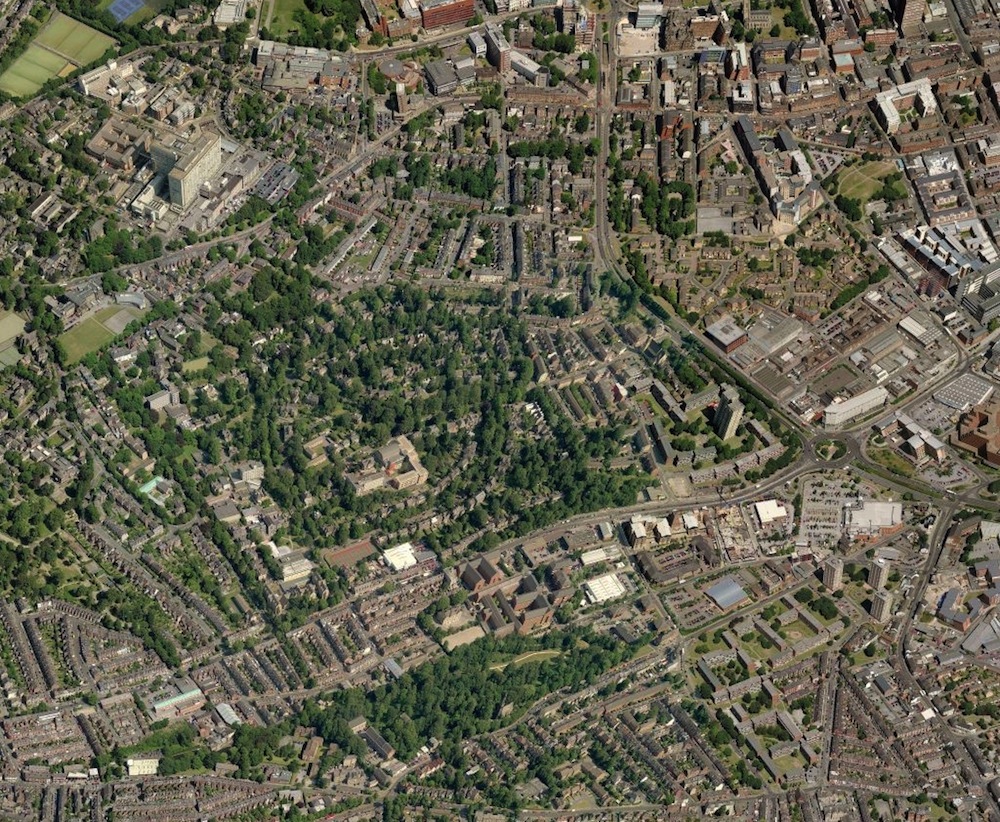
More on the nature of its identity later. At the beginning of our project we asked the question – where is Broomhall? What is our research boundary for our project? Which streets are we including and which are we excluding in all the different directions? How do we come up with our project boundary taking into account historical facts, local knowledge and map evidence?
If you ask people who live in this neighbourhood of Sheffield today they will tell you it is a vibrant, diverse community with people living here from all over the world. But what or where do the people who live here relate to as ‘Broomhall’?
In recent years it has been defined perhaps by the boundary set by local community groups, relating to their local activities and where they saw themselves serving.
Residents of the 1990s Springfield estate on the ‘other side of the ring road’ may say “I live on the Springfield Estate”, some may say “I live in Broomhall”, some may say “Near Ta’rn” (Town). Most of us who work in Broomhall include ‘that side of the ring road’ in Broomhall and the ‘Broomhall Flats’ used to stand there in the 1960s to 1980s and the flats were referred to by Broomspring Centre staff simply as ‘Broomhall’ and other areas nearby were called Hanover and Havelock, for example, areas which now are certainly ‘in’ Broomhall. Many of the children at Springfield School, some of whom live on the Springfield estate say they live in Broomhall but those who work in the older cutlery buildings near Milton Street on the next streets over don’t call it Broomhall but say they work near town or near the bottom of the Moor. Those who live in the streets at the heart of the area, e.g. Brunswick Street, Clarke Street, etc definitely say they live in Broomhall (unless they are students then they may say, near the University!). Those who live in the Hanover flats on Exeter Drive say they live in Broomhall though there some say they live in “Hanover”.
Those living at the top of Broomspring Lane, Dorset Street & Gloucester Street mainly say “Broomhall” now but some say “Broomhill”! Residents of Broomhall Park may refer to themselves as living in Broomhall Park or Broomhall or Broomhill as some of the present ward councillors cover this area.
If we look at a modern map it ‘sometimes’ mentions BROOMHALL and sometimes it doesn’t say anything at all. Sometimes it is called BROOMFIELD which in fact is an area further north nearer Broomhill, which few people refer to or know of today.
So we already had a lot of different possibilities to start making our project boundaries…then we started looking further back in time…
Historical Boundaries
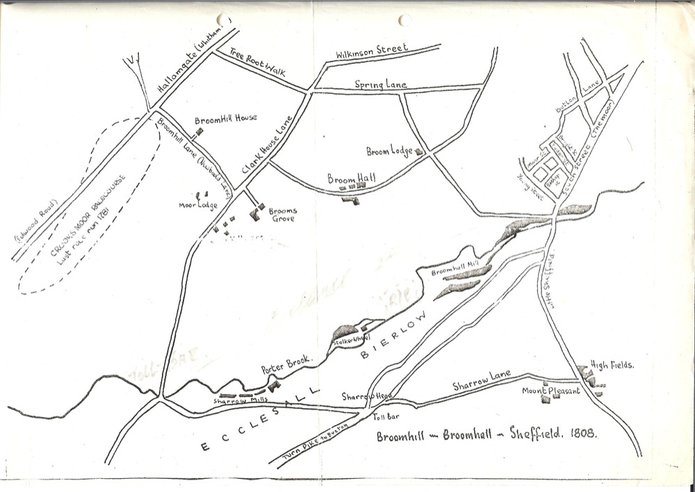
We knew historically that Broomhall is named after the 15th century house Broom Hall and its estate, the Broomhall estate, often called ‘Broomhale’ on older maps. This was a more confined area originally spreading outwards from the present Broomhall Road and Broomhall Street towards town, its lodge house being on the crossroads opposite where St Silas church is now.
Most people in Sheffield don’t think of the area nearer Waitrose and the other side of Ecclesall (Eccy) Road as Broomhall so Eccy Road initially seemed like a possible good boundary for us to set in the South. However, we then discovered that Broomhall Mill and Broomhall Wheel used to be near Napier Street, near Watitrose in the 19th century so we decided to edge our boundary outwards. Then we discovered that people who live on the other side of Eccy Road near the General Cemetery actually have ‘Broomhall’ in their address, and sure enough we found on the old maps this area was called ‘Broomhall Meadows’ on earlier maps. So our boundary spread a little further that way. We decided to make Glossop Road/West Street and Clarkehouse Road our boundaries to the north and west though later in the project we noticed on censuses that the streets nearer the Hallamshire hospital and Children’s hospital were also in the Broomhall area and we wondered if we should have included there too! But as no-one today called that area ‘Broomhall’ today we left it out. The Hallam campus on Collegiate crescent was our western boundary when we discovered the next ‘estate’ over was the original Southgrove estate and separate to the Broomhall estate. It threw us a little however when we saw that Sheffield Archives had images listed under Broomhall that included the Botanical gardens and streets almost up to Hunters Bar. We then discovered that the Broomhall estate had in fact at one time sretched that far. We decided however to still limit our project boundary to Southgrove Road.
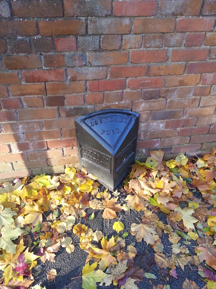
Then there’s parish boundaries – as anyone who does history research knows parish boundaries change and grow and expand and shrink all the time. We discovered that most of the present day Broomhall lies in the old Eccesall Bierlow parish and some in Nether Hallam and some in Sheffield – useful to know when searching the censuses! It is interesting that these three parishes meet in Broomhall and there are two significant boundary posts nestled away on our streets to show where they converge (see parish boundary photo to right).
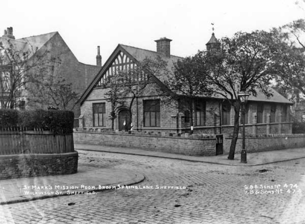
And then you get the church parish boundaries which change constantly as churches are built and dissolved! We knew St Mark’s have for a long time had an involvement in Broomhall, “but aren’t they in Broomhill we thought!?”….then there is the now derelict St Silas church which stands in Broomhall, listed in all its records as within the parish of Gilcar! “Gilcar! “Where’s Gilcar!?” we thought. Then we discovered this area was named after an old fieldname Gill Carr and probably a person too called Mr Carr and mainly covered the area to the east of the church in the area now known as towards ‘tarn or near the bottom of the moor, but an area saturated in the cutlery industry, and known as Broomhall to those that lived there in the early and mid-20th century. We discovered that St Mark’s parish boundary went as far down as Hanover Street and Brunswick Street which explained why they had built the St Mark’s mission room in 1905 on the corner of Brunswick Street and Broomspring Lane. Then we found out St Mark’s used to be called ‘St Mark’s, Broomhall’ and was only changed to St Mark’s, Broomhill in the 1990s by its then vicar, Rev Adrian Alker. But then someone we knew who had grown up in the 1940s on Dorset Street, off Broomspring Lane, said they definitely grew up in Broomhill not Broomhall and can’t understand why St Mark’s thought itself was ever Broomhall…oh and somewhere in all that St Mark’s parish was in fact bigger and extended as far as St Jude’s parish near the present Devonshire Green, before they built St Silas in 1869 which meant then of course there was a new parish called St Silas, Gilcar, that took over a chunk of it….
And then over the Eccy Road, near the cemetery, that place where no one now calls it Broomhall, unless you have it on your address…that was part of St Matthias parish…but eventually this closed and so the boundaries amalgamated again…in fact St Mark’s parish boundary changed many times during the 20th century…and then in 2000 St Silas closed and so the next parish over, St Mark’s, now St Mark’s, Broomhill that used to be St Mark’s, Broomhall, now got renamed St Marks, Broomhill & Broomhall!
Are you keeping up ok?!
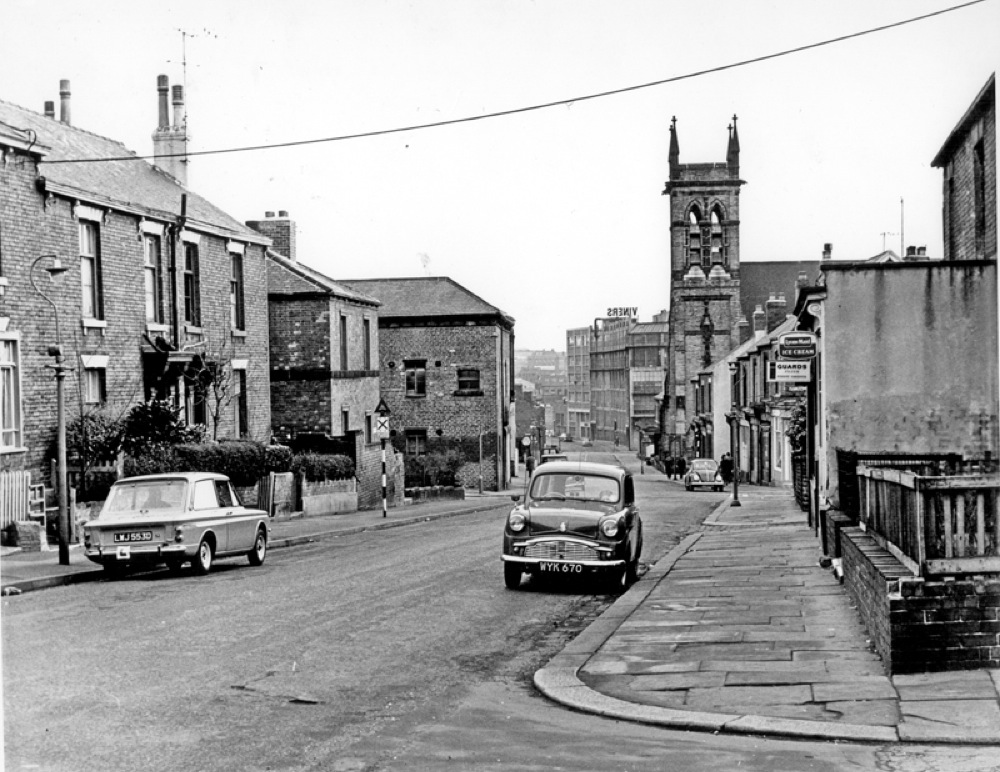
So…ask those people we have interviewed who grew up in Broomhall in the 1940s, 1950s, 1960s and they will tell you how it used to look before the ring road came in the 1960s and effectively cut Broomhall in half. The then Clarence Street and Aberdeen Street, seen on old maps, and an array of others streets of back-to-backs now demolished looked like a completely different place. Clarence Street became the bottom of the now Hanover Way, and the old Hanover Street, one of the oldest streets in the area, was virtually side railed – pedestrianized at its bottom near the Hanover tower block and maisonettes and sneaked over to become the road adjacent to the ring road and blocked off at its top end. Broomhall Street, originally the ‘main road’ into town full of hundreds of shops has been swallowed up and now only bits of it at either end exist, some morphing into Broomhall Road at the junction with Broomhall Place and Wharncliffe Road and some near Springfield school and right up to West Street near the Green Room bar and Within Reason.
Ward Boundaries
In 2014 the local council put out a consultation relating to the Ward boundaries for voting. Presently part of Broomhall is in the Central Ward and some of it is in Broomhill Ward. Suggestions were put forward that everything west of the ring road should be blended into Broomhill Ward and everything east of the ring road blended into Sheffield City Centre Ward…cutting us in half again and virtually diluting the name Broomhall again….we managed to win our argument that the whole of Broomhall should stay in one ward or the other and not be split in two…but on what basis can we argue where Broomhall actually is?! Mainly based on where residents today identify themselves as Broomallians we asked if the Springfield Estate (on the other side of the rind road) could be included and not be swallowed up into ‘Sheffield city centre’ ward….they eventually agreed and now the Springfield estate is included in the newly named Broomhill & Sharrow Vale Ward, along with the rest of Broomhall (except Gell Street and Victoria Street which we call ‘Broomhall’ but is now part of tarn’!)… and ironcially almost all of Broomhall is now in a ward called Broomhill and Sharrow Vale!
We had spotted in Victorian newspapers and trade directories that Broomhall had its very own political Ward and representatives then so why now had it become so diluted…
Council Boundaries
Why also had the recent road improvement scheme company, Amey, called our area ‘Broomfield’? Where was Broomhall? Did their workers know where they were when re-paving our streets?! The mystery deepened….
By chance I was looking up the cycle paths in Sheffield on the City council website and noticed that Broomhall wasn’t even mentioned on the maps they were using….but Broomfield was! That explained why Amey called it that! So was the neighbourhood of Broomhall invisible even to the local council!? We contacted the council…they said they base their maps on the Ordnance Survey map…’ah well that explains it then’ we thought…we contacted Ordnance survey to ask if we could be put back on the map please…they told us they base their map on what the local council tell them! ….many emails later and that is now to be changed and we will now literally have the words ‘Broomhall’ put back on the map! Watch this space!
Area Perceptions
Throughout the project we have told others who don’t live here that this is a project about Broomhall…we get mixed responses…such as “I used to live in Broomhall”….”ooh not a nice place”…”not a safe place”…”I remember it down there in the 80s”…”drugs…red light district…shootings”….”Wasn’t that where they caught the Yorkshire Ripper?”…
Its reputation is linked to what it is known for in its streets…literally…
One day I was walking through Broomhall Park and heard a child ask her mum where they were….”Oh Broomhill I think”, she answered…we constantly hear people calling us Broomhill by mistake…we’ve even not given people jobs in our project because their application called us Broomhill instead of Broomhall (we’ve nothing against Broomhill you understand, it was more a sign perhaps that they hadn’t paid attention to the aim of our project!).
So we decided to survey some of the people who pass through our area.hundreds of people a day walk through it and up and down our streets, between the hospital or university and ‘tarn’.
Many knew they were in Broomhall but most just said near the university or hospital…one even said Sharrow!
Broomhall seems to be a passing place, yet a place people like to pass through, with its leafy trees and historic houses, a place people arrive to live when they arrive from other countries, a place families settle, even if just for a while, a place students stay in for part of their time in Sheffield.
Concluding Musings
So we come full circle. We have concluded through doing our project that Broomhall has been in different places over the years and is still modifying year by year as the decades roll. What we have learnt is that boundaries constantly change in all areas and allocation of place meaning is shifted constantly, and often from generation to generation.
What is clear is that the present local perception of Broomhall for those that live here now and those that lived here in its illustrious past is that it was and is a place of community and meaning, a place people treasure, a place that far surpasses its past negative reputation as an inner ghetto full of drugs, crime and prostitutes.
Google ‘Broomhall, Sheffield’ and you will get a few results that are our Broomhall in Sheffield. When we first wrote our project bid for the heritage lottery fund, we would google ‘Broomhall, Sheffield’ and get hundreds of Broomhill links.
We did this project to put OUR Broomhall back on the map and to give it back its positive identify. And we feel we have gone a long way towards achieving this.
According to official figures the percentage of black and minority ethnic (BME) people living in Broomhall increased from 36% to 67% between 2001 and 2006 and is thought to have increased since then. There is a large Somali community higher than the average for the city, and the Black/Black British Communities overall is 11.3% compared with Sheffield average of 1.8%. The Asian community here is 7.8% compared with a 4.6% Sheffield average. There are also an increasing number of economic migrants from Eastern Europe moving into the area. The proportion of Broomhall BME children in primary schools is much higher than the city average and is increasing. In 2004 the percentage of Broomhall BME children was 77.7% increasing to 80.3% in 2008. When we ran our local school workshops one of the classes we worked with was 100% BME and mainly from Somali and Arabic speaking countries.
Some people in Sheffield think Broomhall is where all the people get put from other countries; in other words that it’s maybe too diverse. But, this view is largely based on ignorance. What our historical research has found is that people from other countries have been living in this area for over a hundred years. We have found immigrants on censuses from Russia, Germany, Italy, India, Australia, USA etc and equally many stories of people leaving Broomhall to move on to pastures new in countries such as Australia.
You might think we’re making a fuss over nothing. Certainly we could come across as a bit arrogant and over proud of our area. But at the end of the day boundaries do matter. Broomhall ranked as 33 out of Sheffield’s 100 most deprived neighbourhoods. However, the true nature of deprivation is masked by there being many student occupancies and some very wealthy residences in parts of Broomhall. This has in the past had a knock on effect on the amount of funding the area receives.
We want to share our history with a wider audience to improve and develop a positive profile of Broomhall within Sheffield. Broomhall continues to suffer from negative socio-cultural stereotypes within Sheffield, which strongly contrasts with the living reality of those who reside there and who find it a great place to live. For many who do not live here, it is simply a ‘passing place’ from the university to the city centre. It is as if Broomhall as an area doesn’t exist for some. Broomhall is perceptively divisible into two, half appears as a more working-class and immigrant area, the other being perceived as a more affluent houses/university area (once a gated community in the 1800s and 1900s.)
By looking at the heritage of both parts of the neighbourhood we hope we have strengthened the links across this divide and begun to build stronger bridges across cultures and communities, enhancing the social identity of Broomhall as a whole. Broomhall ‘is’ one of the main ‘gateways’ for immigrants arriving into the city. Often this is seen as a negative but we wanted to show how this diversity makes ‘Broomhall’ the vibrant place it is today.
As you walk our streets, either to enjoy its rich history and buildings, or simply to pass through, we hope you have a positive feeling that you are in ‘Broomhall’, perhaps a place with ever-changing and shifting boundaries, but still a place to enjoy passing through and indeed, a place many call home.


Comments about this page
hiya, I spent my younger years in the broomhall district, I went to springfield school from 1943 until 1953 and left the district when I was 23 years old, I lived on bath st which was just below the school, I counted the many shops that there were on broomhall st close by and one of the biggest number was the pubs there were 26 within a quarter of an hour’s walk of where I lived and I can still name them all, when I was at an early age at school the teachers used to walk us from school to the botanical gardens,we would walk along broomhall st all the way to park lane up to clarkehouse rd turn left at the top and into the gardens we would spend time around the bear pit and the surrounding wood land.
I read about the lodges I can remember 4 of them.
Add a comment about this page